There’s something surreal about leaving wide-open prairie skies behind and ending your journey on an island surrounded by mountains, coastal waters, and quiet shoreline towns.
One moment you’re driving through Alberta’s open landscapes. A few hours later, you’re winding through mountain passes, stopping at glacier-fed lakes, crossing canyon highways, following one of the most scenic routes in Canada, and eventually boarding a ferry toward Vancouver Island.
This isn’t just a drive from point A to point B.
It’s a journey through entirely different worlds.
This guide breaks down the best stops, Highway 99 highlights, ferry tips, what to pack, and how to make the trip smooth, scenic, and memorable without feeling rushed.

Why This Road Trip Is So Unique
This route transitions through multiple landscapes in a single journey:
- prairie landscapes
- Rocky Mountain peaks
- glacier-fed lakes
- canyon deserts
- winding alpine highways
- coastal ferry crossings
- island shoreline towns
And the best part is that most of the most beautiful places are easy roadside stops.
What I’d Pack for This Road Trip Again
This route involves long driving days, remote stretches, ferry travel, and constant scenic stops.
These are the things that genuinely made the trip easier and more comfortable.
Large insulated water bottle
Long stretches of Highway 99 and interior BC can go by without easy stops.
Having cold water on hand saves money and keeps you comfortable during long driving days.
Paper road atlas or BC highway map
Old-school, but incredibly useful in areas with weak signal or unexpected detours.
It also helps you understand the bigger geography of the route instead of relying only on GPS.
Car phone mount
Highway 99 has winding roads, mountain curves, and constant pullouts.
A phone mount makes navigation safer and much easier to manage.
Roadside emergency kit
Some stretches near Lillooet feel remote, with fewer services available between towns.
A basic emergency kit adds peace of mind for long drives.
Travel cooler
This is one of the best money-saving items for the entire trip.
It allows you to stock up on groceries in places like Whistler instead of relying on expensive roadside food.
Comfortable walking shoes or hiking sandals
Many of the best stops on this route involve short walks to waterfalls, lakes, and viewpoints.
Good footwear makes spontaneous stops effortless.
Lightweight phone tripod
Perfect for solo travelers or anyone wanting better photos at scenic stops without rushing or asking for help.
Stop 1: Canadian Rockies Begin the Journey
Lake Louise
One of the most iconic lakes in Canada.
Arrive early in summer because parking fills quickly and crowds build fast.
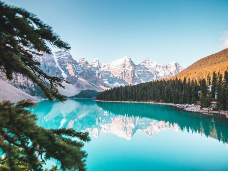
Moraine Lake
A stunning turquoise lake surrounded by dramatic peaks.
One of the most photographed places in the country.
Emerald Lake
A quieter alternative to Banff’s main lakes.
Calm, reflective, and perfect for a peaceful stop.
Spiral Tunnels Viewpoint
A quick roadside stop where trains loop through mountain tunnels.
Short stop, unique experience.
Stop 2: Break the Drive in Revelstoke
Revelstoke is one of the best overnight stops on this route.
It breaks up the drive and gives you access to mountain scenery without rushing.
If time allows, explore Mount Revelstoke National Park for panoramic viewpoints and alpine scenery.
Stop 3: Interior British Columbia Canyon Drive
Near Lillooet, the landscape shifts dramatically.
You’ll notice:
- dry canyon walls
- wide river valleys
- winding roads
- fewer services between towns
This section feels completely different from the Rockies and is often unexpected for first-time travelers.
Stop 4: Highway 99 (One of Canada’s Most Scenic Drives)
This is where the trip becomes unforgettable.
Duffey Lake Provincial Park
A stretch filled with glacier-fed lakes, mountain pullouts, and constant viewpoints.
This is not a section to rush.
Pemberton
A peaceful valley surrounded by farmland and mountain peaks.
A great place to rest and refuel before continuing.
Brandywine Falls Provincial Park
A short walk leads to a powerful waterfall dropping into a canyon.
One of the easiest scenic stops on the route.
Stop 5: Whistler Break Stop
Whistler is the perfect place to slow down before the coast.
This is where most travelers:
- restock groceries
- take a break from driving
- walk through the village
- prepare for ferry travel
A travel cooler becomes especially useful here for keeping food fresh and reducing travel costs.
Stop 6: Sea to Sky Highway Before the Ferry
Shannon Falls Provincial Park
A quick stop with a powerful waterfall view right off the highway.
Sea to Sky Gondola
One of the most impressive viewpoints in British Columbia.
Mountains and ocean views come together in a single panorama.
Ferry Crossing to Vancouver Island
Horseshoe Bay Ferry Terminal → Nanaimo via BC Ferries
A key part of the journey that connects the mainland to Vancouver Island.
Tips for the ferry:
- arrive 45–75 minutes early in summer
- payment is made at the terminal
- bring snacks for waiting times
- keep devices charged for the crossing
Arriving on Vancouver Island
Whether you end your journey in Comox, Nanaimo, or Victoria, the pace immediately slows.
Expect:
- coastal towns
- beaches and shoreline views
- marina harbours
- mountain silhouettes across the water
- quieter, slower travel days
After days of driving, this shift feels like a reward.
Bonus Return Stop: Canyon Hot Springs
Canyon Hot Springs is one of the best places to stop on the return journey.
It’s ideal for:
- relaxing after long drives
- breaking up the trip home
- enjoying a quiet mountain setting
Why This Road Trip Stays With You
This route is not just a drive.
It’s a transition through entirely different landscapes in a single journey:
prairies → mountains → canyons → lakes → waterfalls → coastal highways → ferry crossings → island shoreline towns
And the best advice is simple:
Don’t rush it.
Pull over often.
Let the journey unfold naturally.
This post may contain affiliate links. If you purchase through them, I may earn a small commission at no extra cost to you. Thank you for supporting my adventures.